Bowes Railway
Bowes Railway was originally a colliery railway built to carry coal mainly from pits in north west Durham to the Tyne at Jarrow. The earliest section was designed by George Stephenson and opened on 17 January 1826, making it one of the world's first modern railways.
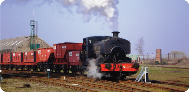
It was 15 miles long when completed in 1855. Each end was locomotive worked; the six mile middle section consisting of rope worked inclines with very steep gradients. At its peak, the Railway handled over 1 million tons of coal per year and remained virtually intact until 1968.
Between 1968 and 1974, most of the line was closed until only the last 3.5 miles between Monkton and Jarrow staithes were operated by the National Coal Board. However, the original 1826 section between the Black Fell bank head and Springwell bank head was acquired for preservation in 1976 by Tyne and Wear County Council.
This comprises Blackham's Hill West and East inclines, which are operated by a stationary haulage engine. It is the only working preserved standard gauge rope hauled railway in the world. In 1977, the Railway's Engineering and Wagon Shops at Springwell were added to the scheme, providing the facilities needed for maintenance.

Time line
The Bowes Railway was also known as the Pontop and Jarrow Railway, even though it never was connected to Pontop Colliery as origionally planned. When complete in 1855 it ran from Dipton to Jarrow.
1826 - the first section opened from Jarrow to Springwell Colliery. There was a self-acting incline from Springwell Colliery down to Lingey Lane. This incline was still working in the 1960s. Locomotives were used from Lingey Lane to Jarrow. The original line near Jarrow was abandoned when new staiths were built at Hebburn.
Blackham's Hill, or Blackim Hill stationary steam engine worked inclines down to both Springwell Colliery and Mount Moor.
1842 - with a hauling engine at Mount Moor, the line was extended down the east side of Team Valley and then up the west side to Kibblesworth Colliery. This is now a cycle route under the ECML.
1845 - using a former wooden waggonway route, coal from Burnopfield Hobson Pit ran to Marley Hill and then down the Tanfield Railway to Redheugh.
1854 - the line from Marley Hill to Kibblesworth was opened. A level crossing was made with the Tanfield Railway at Gibraltar Crossing.
1855 - the final section opened from Burnopfield via Pickering Nook to Dipton Delight Colliery.
1947 - the line became part of the National Coal Board.
www.bowesrailway.co.uk - Bowes Railway Museum is at Springwell Colliery.
Springwell Colliery - The aerial photo shows the pit for the return wheel at the top of the self-acting incline on the Bowes Railway. Loaded waggon sets descending the incline hauled empty waggons up to Springwell. Only three rails were needed, with the centre rail used by both up and down trains. At the halfway point the centre rail divided so that trains could pass each other. A brakesman controlled the speed of the return wheel from the signal box. With a mile of steel rope running on cast-iron rollers, the noise could be heard from a distance.
At night a burning coal brazier was the "headlight" when the train crossed Leam Lane.
Microsoft Virtual Earth - Birds Eye View of Springwell Colliery. You can use this link to view the whole cycle route.
